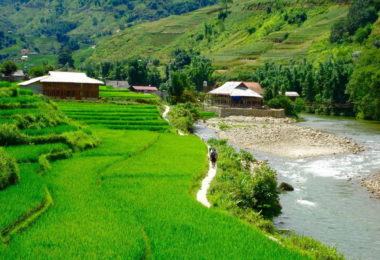
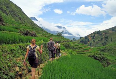
Sapa is a town in the highlands, is a famous hill-station of Sa Pa District, Lao Cai Province, Vietnam. It is covered by many wonders of nature, natural landscape and topography of the mountains, the green of the trees, making a painting with harmonious compositions, with romantic scenery and attractive landscape earth northwest region.
Location: Sa Pa town is located on the ground at 1,500 to 1,650 meters in the mountainside of Suay Lo Tong. The peak of this mountain can be seen in the southeast of Sapa, with an elevation of 2228 meters. From the town overlooking the valley to the east and Ngoi Dum Muong Hoa valley in southwest
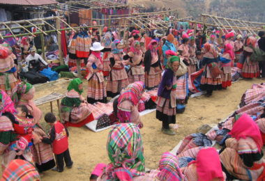
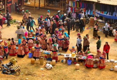
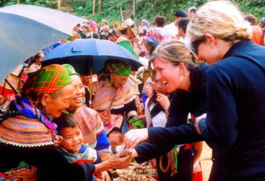
Climate: Located in the northwest of Vietnam, Sapa town at an altitude of 1,600 meters above sea level, it is 38 km from Lao Cai city and 376 km from Hanoi capital. Apart from the main roads from the city of Lao Cai to Sapa, it also is a route to other traffic that is connecting Highway 4-D Binh Lu, Lai Chau. Although the majority of Sa Pa district residents are from ethnic minorities, the town focuses mainly on the Kinh people in agriculture and tourism services.
Located in northern Vietnam, Sapa has a subtropical climate but is situated at a high altitude due to cool air throughout the year. In summer the weather in town for one day with all four seasons: the morning is spring weather, noon weather like in summer, usually mild sunshine, balmy climate, afternoon clouds, and mist falling induce feeling cold fresh autumn air and the cold night of winter. The average air temperature in Sapa town is at 15 ° C. In the summer, the town does not have so much sun, it is about 13 ° C - 15 ° C at night and 20 ° C - 25 ° C in the daytime. In the winter, it often is cold, the cloud covers, and temperatures sometimes are below 0 ° C, sometimes with snow. Average annual precipitation is from 1,800 to 2,200 mm, mostly concentrated in the period from 5 to August.
Sa Pa Town is one of the places that have snow in Vietnam. In the period from 1957 to 2013, has 21 times with the snow in Sapa. The biggest snowfall was on February 13, 1968, continuously from 3.00 am to 2.00 PM, it was with the thick of 20 cm.
History: In 1897, the French colonial government decided to open an investigation on ethnic minority highland. The first investigation group to Lao Cai in 1898. Winter 1903, while conducting measurements mapping expedition geography of Indochina Department discovered the landscape of Sa Pa Tung Village. This work marked the launch of Sapa town.
In 1905 the French had collected the first information about the geography, climate, vegetation ... Sapa began to be known as the cool air, the fresh and beautiful scenery. In 1909 a built resorts. 1917, a tourist office was established in Sapa and a year later, the French began to build the first villas. In 1920, the railway Hanoi - Lao Cai accomplished, Sapa is considered the summer capital of North Vietnam. In total, the French had built nearly 300 villas in Sapa.
Sapa devastated by the border war in Vietnam - China 1979. Thousands of hectares of pine forests covering the town were burned, many ancient villas were built by France also destroyed. In the 1990s, Sapa was built, rebuilt again. Many hotels, the newly built villa. From the 40 rooms in 1990, up to 300 rooms in 1995. In 2003, Sapa has about 60 large & small hotels with 1,500 rooms. The number of tourists coming to Sapa increased from 2,000 visitors in 1991 to 60,000 in 2002.
Sapa name: Sapa's name is derived from Mandarin. In Mandarin pronounced SA PẢ or "Sand" because of Sapa town is here only a sand ground where was local people often used for the marketplace.
What do you do in Sapa town?
Visit the famous visiting tourist attraction like as: Ham Rong Mountain, Sapa Church, Sapa market
Food: Local restaurant: Good Morning View Sapa Restaurant, Moment Romantic Restaurant, Luckydaysy’s Bamboo, Ninety Pub & Bar, Anise Restaurant, Turing in.
Drink: The H'mong Sisters, Wooden PUB, Xin Chào Pub, Blue Loco Bar & Hostel